


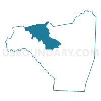
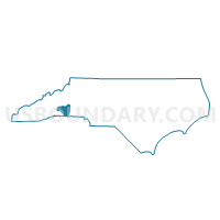
Voting District 16A, Rutherford County, North Carolina
About
Outline

Summary
| Unique Area Identifier | 641356 |
| Name | Voting District 16A |
| County | Rutherford County |
| State | North Carolina |
| Area (square miles) | 55.94 |
| Land Area (square miles) | 55.91 |
| Water Area (square miles) | 0.03 |
| % of Land Area | 99.95 |
| % of Water Area | 0.05 |
| Latitude of the Internal Point | 35.47122830 |
| Longtitude of the Internal Point | -82.04579270 |
Maps

Graphs
Select a template below for downloading or customizing gragh for Voting District 16A, Rutherford County, North Carolina


Neighbors
Neighoring Voting District (by Name) Neighboring Voting District on the Map
- Voting District 04A, Rutherford County, NC
- Voting District 06A, Rutherford County, NC
- Voting District 18, Rutherford County, NC
- Voting District 27, Rutherford County, NC
- Voting District 28, Rutherford County, NC
- Voting District CCREEK, McDowell County, NC
- Voting District GLENWD, McDowell County, NC
- Voting District M.COVE, McDowell County, NC
Top 10 Neighboring County Subdivision (by Population) Neighboring County Subdivision on the Map
- Rutherfordton township, Rutherford County, NC (13,107)
- Logan Store township, Rutherford County, NC (3,904)
- Crooked Creek township, McDowell County, NC (3,527)
- Green Hill township, Rutherford County, NC (2,878)
- Chimney Rock township, Rutherford County, NC (2,666)
- Montford Cove township, McDowell County, NC (2,541)
- Gilkey township, Rutherford County, NC (1,952)
- Morgan township, Rutherford County, NC (1,592)
- Camp Creek township, Rutherford County, NC (1,299)
- Brackett township, McDowell County, NC (476)
Top 10 Neighboring Unified School District (by Population) Neighboring Unified School District on the Map
Top 10 Neighboring State Legislative District Lower Chamber (by Population) Neighboring State Legislative District Lower Chamber on the Map
Top 10 Neighboring State Legislative District Upper Chamber (by Population) Neighboring State Legislative District Upper Chamber on the Map
Top 10 Neighboring 111th Congressional District (by Population) Neighboring 111th Congressional District on the Map
Top 10 Neighboring Census Tract (by Population) Neighboring Census Tract on the Map
- Census Tract 9605, Rutherford County, NC (8,018)
- Census Tract 9602, Rutherford County, NC (6,973)
- Census Tract 9601, Rutherford County, NC (6,265)
- Census Tract 9709.02, McDowell County, NC (5,097)
- Census Tract 9708, McDowell County, NC (4,227)
- Census Tract 9603, Rutherford County, NC (2,625)
Top 10 Neighboring 5-Digit ZIP Code Tabulation Area (by Population) Neighboring 5-Digit ZIP Code Tabulation Area on the Map
- 28752, NC (30,600)
- 28043, NC (21,055)
- 28139, NC (20,111)
- 28762, NC (6,857)
- 28746, NC (2,388)
- 28167, NC (2,362)